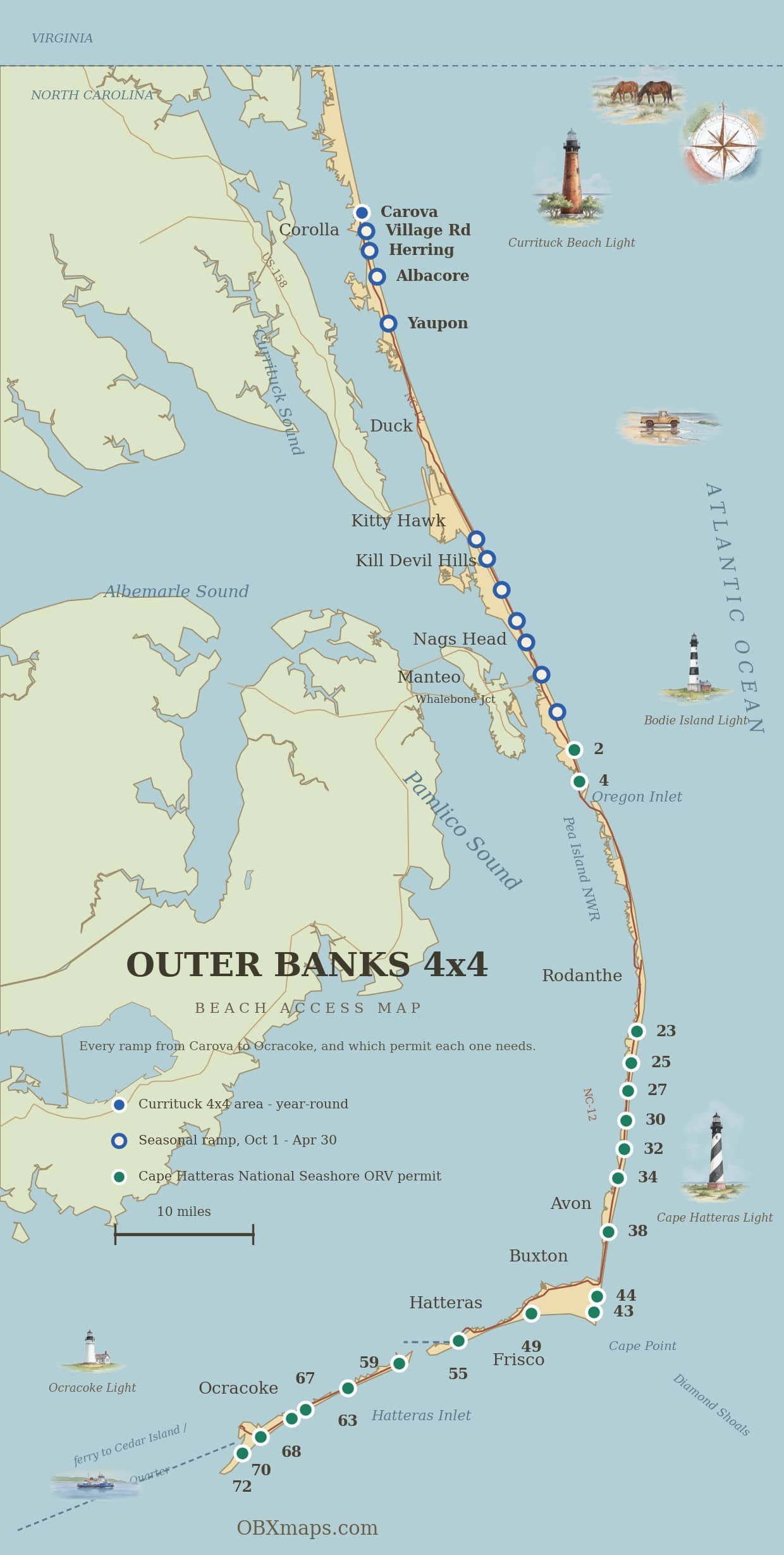
The Outer Banks has more than 50 official beach access points where you can drive on the sand, stretching from the Virginia border at Carova all the way south to Ocracoke Inlet. They’re split across three jurisdictions with very different rules. This page maps every official access point and links you to a dedicated guide for each one — with aerial views, hours, permit requirements, and tips.
Corolla · Nags Head · Hatteras · Ocracoke
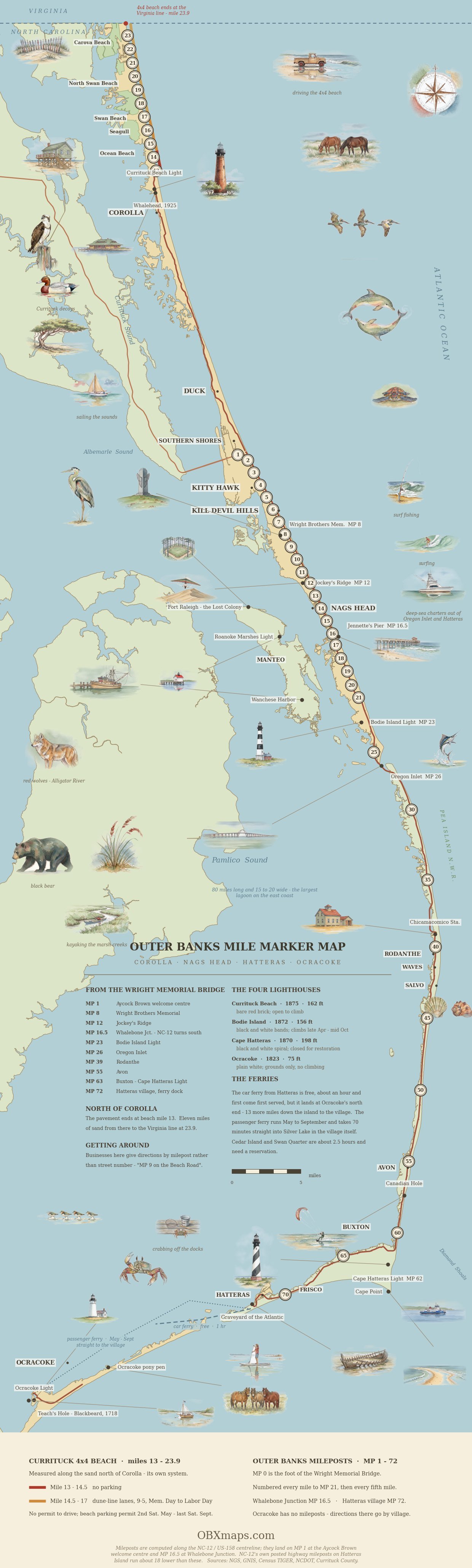
The Outer Banks Mile Marker Map
The ramp map below shows where you can get on. This one shows the coast the way people give directions on it — by milepost — with the lighthouses, the landmarks and the wild stretches drawn in.
Ramp Locations at a Glance
For the wider picture, including the Currituck 4x4 area north of Corolla, see our sister site OBXmaps and its Outer Banks 4x4 beach access map.
Take it with you. Signal thins out south of Salvo and on the Carova sand. Open our ramp map in Google Maps before you leave the paved road and save it to your phone for offline use.
Why Ramp 48 has no pin. It is the one ramp you cannot reach from NC-12. Under the National Park Service rule it is a spur off the Inside Road, the sand track running between Ramp 44 and Ramp 49, and no source publishes its coordinates. It sits about a mile east of Ramp 49 along South Beach and marks the east end of the drivable Frisco beach: the vehicle-free stretch toward Cape Point begins just past it. It is a priority ramp, open from 6:30 a.m. See the Ramp 48 guide.
Every ORV Ramp, North to South
Ramp numbers run north to south down the seashore. The season column is the rule set by the National Park Service, not today conditions: ramps also close temporarily for bird and turtle nesting, so check the NPS beach access status page before you air down.
| Ramp | Island | Nearest village | ORV season | Guide |
|---|---|---|---|---|
| Ramp 2 | Bodie Island | Coquina Beach | ORV ramp; beach north of it is walk-in | Ramp 2 guide |
| Ramp 4 | Bodie Island | Oregon Inlet | Year-round | Ramp 4 guide |
| Ramp 23 | Hatteras Island | Salvo | Oct 15 to Apr 14 | Ramp 23 guide |
| Ramp 25 | Hatteras Island | Salvo | Year-round | Ramp 25 guide |
| Ramp 27 | Hatteras Island | Salvo | Year-round | Ramp 27 guide |
| Ramp 30 | Hatteras Island | Salvo | Year-round | Ramp 30 guide |
| Ramp 32 | Hatteras Island | Avon | Year-round | Ramp 32 guide |
| Ramp 34 | Hatteras Island | Avon | Oct 15 to Apr 14 | Ramp 34 guide |
| Ramp 38 | Hatteras Island | Avon | Oct 15 to Apr 14 | Ramp 38 guide |
| Ramp 43 | Hatteras Island | Buxton | Year-round | Ramp 43 guide |
| Ramp 44 | Hatteras Island | Buxton | Year-round | Ramp 44 guide |
| Ramp 48 | Hatteras Island | Frisco, via Inside Road | Year-round | Ramp 48 guide |
| Ramp 49 | Hatteras Island | Frisco | Year-round | Ramp 49 guide |
| Ramp 55 | Hatteras Island | Hatteras Village | Year-round south; Oct 15 to Apr 14 in front of the village | Ramp 55 guide |
| Ramp 59 | Ocracoke Island | North Ocracoke | Year-round | Ramp 59 guide |
| Ramp 63 | Ocracoke Island | North Ocracoke | Year-round | Ramp 63 guide |
| Ramp 67 | Ocracoke Island | Mid-island | Year-round | Ramp 67 guide |
| Ramp 68 | Ocracoke Island | Ocracoke | Oct 15 to Apr 14 | Ramp 68 guide |
| Ramp 70 | Ocracoke Island | Near the airstrip | Year-round | Ramp 70 guide |
| Ramp 72 | Ocracoke Island | South Point | Year-round | Ramp 72 guide |
Ramp 2 is an ORV ramp: the route runs two miles south of it, and the beach north of the ramp is walk-on only. Every ramp on this list needs a Cape Hatteras National Seashore ORV permit on the windshield.
The Three Jurisdictions
Outer Banks beach driving falls under three different authorities, each with its own rules, permits, and seasons — plus a few towns where beach driving is not allowed at all:
- Currituck County (4x4 Area): Year-round driving. A Currituck County beach parking permit is required to stop or park on the 4WD beach during the seasonal permit window. From the end of NC-12 in Corolla to the Virginia line.
- Towns of Kill Devil Hills & Nags Head: Seasonal beach driving with a paid town permit, typically Oct 1 – Apr 30 (summer driving prohibited). Town-managed ramps.
- Cape Hatteras National Seashore (NPS): Paid ORV permit required year-round. The largest stretch, from Oregon Inlet through Hatteras and Ocracoke islands.
- No-driving towns: Kitty Hawk, Duck, and Southern Shores prohibit beach driving year-round — no permits are issued.
Northern OBX — Currituck 4x4 Area
The northernmost 11 miles of OBX beach, accessible only by driving on the sand, open year-round. A Currituck County beach parking permit is required to stop or park on the 4WD beach during the seasonal permit window. Home to the wild Corolla mustangs and Penny’s Hill.
- Currituck 4x4 Beach Access Hub — overview of the entire 4x4 zone
- Corolla NC-12 4x4 Beach Access — main entry point at end of pavement
- Swan Beach — first community north of pavement
- Penny’s Hill (Lewark’s Hill) — 40 ft active dune
- North Swan Beach — between Swan Beach and Carova
- Carova Beach — northernmost community on OBX
- Corolla Beach Parking Permit — required to stop or park on the 4WD beach
Northern Beach Towns — KDH, Kitty Hawk, Nags Head
These towns allow seasonal beach driving with a paid permit. Permits are typically valid October through April, with summer driving prohibited. Each town has its own rules and ramps.
- Kitty Hawk (No Driving)
- Kill Devil Hills Beach Driving Permit
- Nags Head Beach Driving Permit
- Duck, NC (Beach Driving Not Allowed)
- Southern Shores (Beach Driving Not Allowed)
Cape Hatteras National Seashore — Bodie Island & Pea Island
The northern section of the National Seashore, from Oregon Inlet south to Rodanthe. Requires an NPS ORV permit (10-day or annual).
Cape Hatteras National Seashore — Hatteras Island
The longest stretch of driveable beach on the East Coast. Ramps 23 through 55 cover Rodanthe, Waves, Salvo, Avon, Buxton, Frisco, and Hatteras Village.
- Ramp 23 (Salvo)
- Ramp 25 (south of Salvo)
- Ramp 27 (south of Salvo)
- Ramp 30 (between Salvo and Avon)
- Ramp 32 (north of Avon)
- Ramp 34 (north of Avon)
- Ramp 38 (Avon)
- Ramp 43 (Buxton)
- Ramp 44 (Buxton, Cape Point)
- Ramp 48 (Frisco)
- Ramp 49 (Frisco)
- Ramp 55 (Hatteras Village)
Cape Hatteras National Seashore — Ocracoke Island
Ocracoke is reached by state ferry from Hatteras (free through 2026) (or paid ferry from Cedar Island/Swan Quarter). Ramps 59–72 cover the island.

- Ocracoke Island Beach Driving Permit Guide
- Ocracoke Ferry with a 4x4
- Ramp 59 (north Ocracoke)
- Ramp 63 (Ocracoke)
- Ramp 67 (Ocracoke)
- Ramp 68 (Ocracoke)
- Ramp 70 (Ocracoke)
- Ramp 72 (south Ocracoke)
Planning Resources
- Where Can You Drive on OBX Beaches? — overview by area
- Beach Driving Rules by Area
- Best Tide Times
- How to Air Down Your Tires
- Pre-Drive Safety Checklist
- Seasonal Closures (Nesting)
- Best 4x4 Vehicles for OBX
Every Ramp on One Map
Carova to Ocracoke
Every ramp, and the permit it needs
Blue is Currituck’s year-round 4x4 area, a hollow ring is a seasonal ramp, green is a Cape Hatteras National Seashore ORV permit. Tap any ramp to open its page.